

Unravelling the Mysteries of the Ancient Maya Civilization Through Modern Technology
Discover how modern technologies like lidar scanning and satellite imaging are revolutionizing our understanding of the ancient Maya civilization, unveiling hidden cities, and providing new insights into this sophisticated society.
 admin
admin
Introduction to the Hidden World of the Ancient Maya Civilization
The ancient Maya civilization left behind a hidden world of centuries-old cities, shrouded in mystery and hidden beneath a vast canopy of greenery. Now, new technologies such as lasers and satellite imaging are helping archaeologists uncover these long-lost treasures.
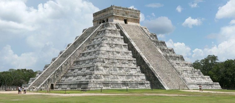
The Maya civilization, which thrived in Mesoamerica from 2000 BC to 1500 AD, is known for its impressive architectural achievements, sophisticated knowledge of mathematics and astronomy, and complex social structure. However, much of their history and culture remain enigmatic, partly due to the dense tropical forests that have concealed their ancient cities for centuries.
Lidar scanning, also known as light detection and ranging, is revolutionising archaeological research by allowing scientists to see through the dense foliage and visualise the hidden structures beneath. This technology uses pulsed laser beams to create highly detailed images of the ground surface, unravelling the mysteries of the ancient Maya civilization.
By precisely measuring the time it takes for the laser beams to return after hitting the ground, lidar scanning creates high-resolution maps of the terrain. These maps reveal ancient structures, road networks, and even subtle elevation changes that can indicate the presence of buried ruins.
With lidar scanning, archaeologists can now explore vast areas of dense jungle terrain more efficiently and effectively. This technology has dramatically accelerated the pace of discovery, allowing researchers to uncover previously unknown ancient cities and gain valuable insights into the daily lives of the ancient Maya people.
In addition to lidar scanning, satellite imaging has played a crucial role in revealing the hidden world of the ancient Maya civilization. Satellites equipped with high-resolution cameras can capture detailed aerial photographs of the dense forests, enabling experts to identify potential archaeological sites and plan targeted excavations.
Through the combination of lidar scanning and satellite imaging, archaeologists have made remarkable discoveries in recent years. They have uncovered ancient temples, palaces, and residential areas that were once home to thriving Maya communities. These findings not only showcase the extraordinary architectural skills of the ancient Maya but also provide insights into their societal structures and cultural practices.
The use of modern technologies to unravel the mysteries of the ancient Maya civilization has opened up a window into the past, allowing us to explore and appreciate the achievements of this remarkable civilization. By combining traditional archaeological methods with state-of-the-art technologies, researchers are gaining a deeper understanding of the Maya's sophisticated society, their connection to the natural world, and the factors that led to their eventual decline.
Revolutionising Archaeological Research: Lidar Scanning and Satellite Imaging
Lidar scanning and satellite imaging are revolutionising archaeological research, providing archaeologists with powerful tools to uncover the secrets of the ancient Maya civilization. These technologies are transforming the way we approach archaeological explorations, allowing us to see through dense vegetation and reveal hidden structures that were once thought to be lost forever.
Lidar scanning, which uses pulsed laser beams to create detailed images of the ground beneath the forest canopy, has proven to be a game-changer in the field of archaeology. By surveying large areas of land from above and emitting rapid laser pulses, lidar scanners can accurately measure the distance between the sensor and the ground surface. This data is then used to create highly precise three-dimensional models of the terrain, uncovering ancient Maya structures that have been concealed for centuries.
One of the most significant advantages of lidar scanning is its ability to penetrate dense forests. With traditional archaeological methods, researchers would have to invest significant time and resources in manually clearing vegetation to reveal potential archaeological sites. Lidar scanning, however, allows us to survey large areas quickly, providing a comprehensive view of the landscape without disrupting the natural environment. This not only saves time but also minimises the impact on the delicate ecosystems surrounding these ancient sites.
By using lidar scanning, archaeologists have made remarkable discoveries, including entire ancient cities and extensive road networks that were previously unknown. These findings have significantly expanded our understanding of the Maya civilization's urban planning, societal structure, and interconnectedness. Furthermore, lidar scanning has revealed the presence of intricate water management systems, such as reservoirs and canals, which play a crucial role in the sustainability of Maya cities.
But lidar scanning is not the only technology driving archaeological breakthroughs. Satellite imaging is also playing a crucial role in uncovering the secrets of the ancient Maya civilization. Satellites equipped with high-resolution cameras capture detailed aerial photographs of the dense forests, providing archaeologists with valuable information about potential archaeological sites.
By analysing satellite images, archaeologists can identify subtle variations in vegetation patterns, soil composition, and topographical features that may indicate the presence of buried structures or ancient settlements. These preliminary findings can then be further investigated using on-ground surveys and lidar scanning to confirm the presence of archaeological sites and determine their precise locations.
The combination of lidar scanning and satellite imaging has revolutionised archaeological research by enabling us to study vast areas more efficiently and effectively. Instead of relying solely on limited ground-level surveys, archaeologists now have access to detailed aerial views and high-resolution 3D models of the terrain. This multidimensional understanding of the landscape allows for more targeted and informed excavations, ultimately leading to the discovery of previously unknown Maya cities, temples, and other important cultural remnants.
Overall, lidar scanning and satellite imaging have transformed the way we investigate the ancient Maya civilization. These technologies have opened up new possibilities for exploration and shed light on the sophisticated society, remarkable architectural achievements, and cultural practices of the Maya people. As technology continues to advance, we can only expect even more exciting discoveries to come, further unravelling the mysteries of this captivating civilization.
Revealing the Maya Biosphere Reserve: Discoveries and Insights
The Maya Biosphere Reserve in Guatemala is an ecological treasure that not only showcases the diverse flora and fauna of the region but also holds invaluable clues about the ancient Maya civilization. With the aid of lidar mapping, archaeologists have made remarkable discoveries within the reserve, revealing the extent of the Maya's engineering skills and offering new insights into their society.
Lidar mapping, which utilises the same principles as lidar scanning but on a larger scale, has allowed researchers to uncover more than 800 square miles of the ancient Maya civilization within the Maya Biosphere Reserve. This vast area, once densely covered by forests, has now been digitally reconstructed, enabling us to explore the intricate urban landscapes that were once hidden beneath the canopies.
One of the most significant findings within the Maya Biosphere Reserve is the presence of extensive road systems connecting ancient Maya cities. Lidar mapping has revealed a network of causeways and raised highways that facilitated transportation and trade throughout civilization. These road networks stretched for miles, demonstrating the Maya's advanced engineering capabilities and the interconnectedness of their urban centres.
In addition to road systems, lidar mapping has also uncovered the presence of large-scale agricultural terraces, known as "bajos." These terraces, with their carefully engineered irrigation systems and water management techniques, allowed the Maya civilization to sustainably cultivate crops in challenging environments. The discovery of these terraces provides valuable insights into the Maya's innovative agricultural practices and their ability to adapt to different geographical conditions.
Furthermore, lidar mapping within the Maya Biosphere Reserve has revealed the existence of numerous temples, palaces, and other architectural structures. These monumental buildings were once thriving centres of religious and governmental activities. The detailed digital reconstructions obtained through lidar mapping showcase the grandeur of these structures, shedding light on the Maya's artistic and architectural achievements.
Archaeologists are also using lidar mapping data to analyse the spatial organisation of Maya cities within the reserve. By examining the patterns of urban layout and the distribution of different architectural features, researchers are gaining insights into the social structure and political organisation of the ancient Maya. These findings challenge previous assumptions and allow for a more nuanced understanding of the intricacies of Maya society.
The discoveries made within the Maya Biosphere Reserve highlight the significance of this region as a hub of Maya civilization. Prior to the application of lidar mapping, many of these sites were unexplored or partially excavated, leading to gaps in our knowledge of the Maya's urban development and cultural practices. However, with the aid of lidar technology, we can now paint a more comprehensive picture of the Maya civilization and their relationship with the natural landscape.
As lidar mapping continues to reveal more ancient Maya structures within the Maya Biosphere Reserve, it becomes increasingly clear that this region was not only a sanctuary for biodiversity but also a hub of human activity and cultural expression. The Maya people, with their advanced knowledge of engineering, agriculture, and art, thrived in harmony with their environment, leaving behind a legacy that continues to captivate and inspire us today.
Unearthing Ancient Art: The Role of Lidar Technology
The ancient Maya civilization was not only renowned for their architectural marvels and advanced societal structures but also for their intricate and captivating artwork. Throughout the Maya world, numerous examples of ancient paintings and murals have been discovered, offering valuable insights into their beliefs, customs, and daily lives. The role of lidar technology in unearthing and preserving these ancient artworks cannot be understated.
Traditionally, discovering and studying ancient Maya art required extensive exploration and excavation of archaeological sites. However, lidar technology has revolutionised this process by allowing researchers to uncover hidden caves and underground chambers that contain these precious artistic treasures. Lidar scanning has proven to be instrumental in mapping the natural and artificial features of the land, enabling scientists to pinpoint potential cave systems and other underground structures.
Once a potential site is identified using lidar scanning, archaeologists can then explore these hidden chambers, often inaccessible or obscured by vegetation, to uncover ancient paintings and murals. Lidar mapping assists in creating accurate 3D models of these cave systems, providing a precise framework for the excavation and restoration of delicate artwork.
The discovery of ancient paintings in Guatemalan caves is one notable accomplishment of lidar technology. These murals, dating back to 100 BC, depict intricate scenes of mythology, rituals, and daily life, offering unprecedented insights into the beliefs and practices of the ancient Maya. The detailed imagery and vibrant colours of the murals highlight the Maya's artistic talent and their deep connection to spirituality.
Through careful excavation and restoration, archaeologists can preserve these delicate artworks for future generations. Lidar technology ensures that these sites are accurately documented and can be studied in detail without causing harm to the fragile paintings. By mapping the caves and their exact locations within the broader landscape, lidar scanning also aids in developing conservation strategies to protect these unique cultural treasures from natural and human threats.
Moreover, lidar technology enhances our understanding of the context in which these ancient artworks were created. By capturing a comprehensive view of the landscapes surrounding the caves, researchers can identify links between the artistic representations and the natural settings. This contextual understanding provides valuable insights into the Maya's spiritual beliefs, connection to the environment, and artistic expressions.
The unearthing of Maya artwork through lidar technology not only enriches our knowledge of their civilization but also challenges preconceived notions about their culture and achievements. These murals depict a complex society with a sophisticated understanding of artistry, symbolism, and storytelling.
With the aid of lidar technology, archaeologists and art historians can preserve and study these ancient artworks in ways that were previously unimaginable. The high-resolution 3D models created through lidar mapping allow for detailed analysis of the murals' pigments, techniques, and artistic styles. This level of scrutiny enables a deeper appreciation of the mastery and creativity of the Maya artists.
The role of lidar technology in unearthing ancient Maya art is invaluable. It allows researchers to uncover hidden treasures, preserve delicate artefacts, and gain profound insights into the cultural, spiritual, and artistic aspects of the Maya civilization. The integration of lidar scanning in archaeological research continues to reveal secrets hidden within the depths of the ancient Maya world, shedding light on their remarkable artistic heritage.
Investigating the Decline of the Maya Civilization
The decline of the ancient Maya civilization has long been a subject of fascination and debate among researchers. Various theories have been proposed to explain the sudden collapse of this once-mighty civilization in the 8th and 9th centuries AD. Lidar technology, combined with archaeological excavations and research, is shedding new light on the factors that contributed to their downfall.
One prevailing theory regarding the decline of the Maya civilization is environmental degradation and resource depletion. The dense population growth and intensive agricultural practices over several centuries likely placed a considerable strain on the environment. The use of lidar scanning and satellite imaging has revealed extensive deforestation and the manipulation of natural water systems, indicating the Maya's reliance on these resources for sustenance.
Lidar mapping has uncovered vast networks of canals, reservoirs, and agricultural terraces that helped mitigate the impact of periodic droughts. However, prolonged droughts, exacerbated by deforestation and soil degradation, likely pushed the Maya civilization to the brink. Lidar technology provides evidence of the impact of water scarcity on the ancient Maya cities, revealing abandoned agricultural fields and linking them to the decline of urban centres.
Political instability is another significant factor believed to have contributed to the decline of the ancient Maya civilization. Lidar scanning has identified the remnants of defensive fortifications surrounding some Maya cities, suggesting an increase in conflict and warfare during their later stages. These fortified walls, along with evidence of violent destruction within the cities, point to internal strife and political instability as contributing factors to the collapse.
Further evidence of political instability comes from the discovery of abandoned cities and the absence of inscriptions or monuments that mark the transition of power from one ruler to another. The lack of written records hampers our understanding of the dynastic shifts and power struggles that likely occurred within the Maya civilization during its decline.
Additionally, the social and economic complexities of Maya society may have played a role in their downfall. Lidar scanning has revealed large urban areas with a significant wealth disparity, characterised by the presence of opulent elite residences and an impoverished lower class. Inequitable distribution of resources and social tensions within these cities could have contributed to the societal breakdown and eventual abandonment.
By combining lidar technology with archaeological excavations and research, scholars are gaining a more nuanced understanding of the factors that led to the collapse of the ancient Maya civilization. It is clear that a combination of environmental degradation, water scarcity, political instability, and social complexities played significant roles in their downfall.
The exploration and analysis of Maya sites using lidar technology continue to provide valuable insights into the final chapters of this remarkable civilization's history. As our understanding evolves with further discoveries, we move closer to unravelling the complex web of factors that contributed to the decline of the Maya and gaining a deeper appreciation for their enduring cultural legacy.
Redefining the Birthplace of the Maya Civilization: Discoveries in the Yucatan Region
For many years, it was widely believed that the birthplace of the ancient Maya civilization was located solely in Guatemala. However, recent discoveries in the Yucatan region have challenged this notion and prompted a reevaluation of our understanding of Maya origins. Lidar technology, combined with archaeological investigations, is providing valuable insights into the early development of Maya society in the Yucatan Peninsula.
Lidar scanning has played a crucial role in uncovering the footprint of an ancient Maya mega-society in the Yucatan region. Large-scale lidar mapping has revealed the existence of flourishing cities and complex urban planning dating back over 1500 years. These cities demonstrate the Maya's advanced architectural techniques, urban design, and notable water management systems.
Prior to the application of lidar technology, the Yucatan region was largely viewed as a peripheral area within the broader Maya civilization. However, the extensive road networks, monumental architecture, and evidence of intensive agriculture discovered through lidar scanning now challenge this view. These findings point to a highly organised and interconnected society that thrived in the Yucatan region alongside other Maya centres in Mesoamerica.
One significant discovery in the Yucatan region is the ancient city of Ek' Balam. Lidar scanning has revealed its sprawling size and impressive structures, including a massive ceremonial complex and elaborate palaces. The intricate carvings and ornamentation found within Ek' Balam showcase the artistic and architectural achievements of the ancient Maya.
Lidar technology has also revealed the presence of extensive canal systems and reservoirs in the Yucatan region. These water management systems were crucial for sustaining agriculture and supporting large populations in the Maya cities. The ability of the Maya to adapt to the specific climatic and environmental conditions of the Yucatan Peninsula demonstrates their ingenuity and resourcefulness.
The discoveries in the Yucatan region challenge the traditional view that the Maya civilization originated solely in the lowlands of Guatemala. Instead, they suggest a more complex and dispersed birthplace of the Maya civilization, with multiple centres of development throughout Mesoamerica.
Lidar scanning has allowed us to recognise the significant contributions of the Yucatan region in the early development of Maya society. It is evident that this region played a vital role in shaping the cultural, architectural, and social attributes that define the Maya civilization.
By redefining the birthplace of the Maya civilization, the discoveries in the Yucatan region contribute to a more comprehensive understanding of the ancient Maya and their rich cultural heritage. Lidar technology continues to unveil new chapters in the history of this remarkable civilization, challenging our preconceived notions and expanding our knowledge of their origins and early development.
Water scarcity and its impact on the Maya civilization
Water scarcity played a significant role in the rise and fall of the ancient Maya civilization. The Maya inhabited regions with a complex hydrological system that required careful management of water resources. Lidar technology, combined with archaeological research, has provided invaluable insights into how water scarcity impacted their society and contributed to their ultimate decline.
The Maya civilization developed in areas characterised by seasonal variations in rainfall, making water management a critical aspect of their daily lives. Lidar scanning has revealed extensive networks of reservoirs, canals, and stone conduits that were engineered to capture, store, and distribute water throughout their cities and agricultural areas.
During periods of abundant rainfall, the Maya people would capture and store water in these reservoirs for use during dry seasons. The sophisticated water management systems allowed for the survival of crops, the sustenance of urban populations, and the support of various economic activities.
However, lidar technology has also provided evidence of the challenges the Maya faced in mitigating water scarcity. In some regions, lidar scanning has uncovered abandoned agricultural fields and irrigation canals, indicating the effects of prolonged droughts on their ability to sustain agriculture. The decline of agricultural productivity would have had direct implications for the food supply, economic stability, and overall well-being of Maya societies.
The impact of water scarcity extended beyond the realm of subsistence agriculture. Lidar scanning has revealed the presence of elaborate cisterns, water catchments, and reservoir systems within urban centres. These structures were essential for providing a reliable water supply to the population, especially during dry seasons or in areas lacking natural water sources.
Water scarcity not only posed challenges for sustenance but also influenced social and political dynamics within the Maya civilization. Control over water resources became a crucial aspect of governance and power. Rulers who successfully managed and allocated water resources would have gained the support and loyalty of their subjects, while mismanagement could lead to unrest and conflict.
The available water supply also influenced settlement patterns and the establishment of city-states. Lidar scanning has revealed that Maya cities were often located near perennial water sources such as springs, cenotes, or rivers, ensuring a reliable water supply for their inhabitants.
However, water scarcity may have played a role in the decline and abandonment of Maya cities. Lidar mapping has uncovered evidence of water management systems falling into disrepair or becoming non-functional, coinciding with periods of political instability and population migrations. Prolonged droughts, combined with political unrest and social pressures, likely contributed to the collapse of Maya city-states and the dispersal of their populations.
Studying the impact of water scarcity on the Maya civilization provides valuable lessons for our current understanding of water management and sustainability. It demonstrates the critical importance of water resources in shaping the development and resilience of ancient societies.
Today, as we grapple with the challenges of water scarcity and climate change, the knowledge gained from lidar technology and archaeological research can inform our efforts to manage water resources more effectively. The remarkable achievements and eventual decline of the ancient Maya serve as a reminder of the fragile relationship between societies and their water environments and highlight the importance of sustainable water management practices for the well-being and longevity of civilizations.
Preserving the Legacy of the Maya Civilization: The Role of Modern Technologies
The ancient Maya civilization left behind a rich and complex legacy that continues to captivate and inspire people around the world. Advancements in modern technologies, including lidar scanning and satellite imaging, are playing a crucial role in preserving and safeguarding the treasures of the Maya civilization for future generations.
One of the significant challenges in preserving Maya archaeological sites is striking a balance between exploration and conservation. Traditional archaeological methods often involve excavation, which can cause damage to delicate structures and artworks. However, the advent of lidar scanning has revolutionised the approach to archaeological research by offering a non-invasive means of exploration.
Lidar scanning allows researchers to create highly detailed and accurate 3D models of Maya sites without the need for extensive excavation. This non-destructive method allows for the preservation of the physical integrity of ancient structures while providing valuable insights into their architectural features and spatial relationships.
The detailed digital models created through lidar scanning not only aid in the documentation and analysis of Maya sites but also serve as a valuable reference for conservation efforts. Archaeologists and conservationists can use these models to monitor the state of ancient structures over time, identify areas of deterioration or vulnerability, and devise strategies for their preservation.
Satellite imaging is another modern technology that contributes to the preservation of the Maya legacy. High-resolution satellite imagery provides a bird's-eye view of archaeological sites, allowing for the identification of potential threats such as encroaching development, looting, or illicit excavation. This real-time monitoring enables quick interventions to protect and preserve these culturally significant sites.
Furthermore, satellite imaging assists in the mapping and documentation of the larger landscape surrounding Maya sites. This broader perspective helps archaeologists and conservationists understand the contextual relationships between different sites, settlement patterns, and potential connections to the natural environment. Such knowledge is vital for the development of comprehensive conservation plans that take into account the larger cultural and ecological context.
Modern technologies also contribute to the preservation of the Maya civilization through the digitization and virtual representation of artefacts and artworks. High-resolution 3D scanning and imaging techniques enable the creation of virtual replicas that can be studied, analysed, and shared with researchers, students, and the wider public. This digital preservation ensures that the Maya's artistic and cultural achievements are accessible and can be studied even in the absence of physical access to the original artefacts.
Another aspect of preserving the Maya legacy involves community engagement and education. Modern technologies, such as virtual reality experiences and interactive displays, offer immersive ways to educate and engage people about the history, art, and achievements of the Maya civilization. These technologies can bring the ancient Maya world to life, fostering a greater appreciation and understanding of their cultural heritage among diverse audiences.
The role of modern technologies in preserving the legacy of the Maya civilization cannot be overstated. From non-invasive exploration and documentation to real-time monitoring and virtual representation, these technologies enable us to safeguard the ancient Maya world for generations to come. By integrating science, conservation, and community engagement, we can ensure that the rich heritage of the Maya civilization continues to inspire and inform the world.
TradeFxP Features
If you choose to be a self-employed retail trader, here are a few things we offer:
- The best trading Platform
- No Requotes
- Lowest Spreads
- High-level liquidity
- Interbank connectivity
- Pure STP/DMA/ECN
- Free signals
- Best support
- Crypto Wallet and withdrawals / Deposits (USDT)
- Robust CRM
- TradeFxP wallet
- Once click withdrawal
- Multiple payment options
- Local offices to walk in
- Free VPS
- Free Video Chat / Virtual Meetings
- And many more…
If you choose to be a part of our managed account program:
- All of the above +
- 1-2% Daily Profits
- High-level risk management
- Capital protection
- Only 30% of the capital used
- Negative balance protection
- Our fee is from the profits only
- Monthly profit withdrawal
- Wallet system – Use it like Phonepe, or Google Pay
- Crypto wallet and withdrawals / Deposits (USDT)
- Live monitoring
- MyFxbook Live monitoring
- Copy Trading
- And many more…
Optional: If you do not withdraw your profits for 2 months, our system will use those profits to trade and will keep your 100% capital safe and secure for margin purposes. This is optional, and if you choose not to be a part of it, you can withdraw your profits from the first month itself.
Why 1-2% daily? Can't your managed forex account earn more?
Yes, we can! Remember: greed may be good in the beginning, but in the end, it will destroy everything. You and I know that! Many droplets make an ocean! Join the Managed Account Program and sit back for six months, then look at your account. You'll see that our strategy is good and the best. Do you know what I mean?
If you choose to be a part of us as an introducing broker (IB) or channel partner,
- Industry best Rebates
- Local Office support
- Staff support
- Marketing support
- Marketing materials
- And many more…
Having said that….
You can join our Forex Managed Account program and earn 1-2% profits daily. See for yourself by clicking the below link.
Have a great journey, and may you catch some big waves on your way to prosperity!
To see Ai Forex Trading for real, use these credentials.
- Low-risk strategy:
- Mt4: 112018
- Pw: Allah@101
- Server: tradefxp live,
1. To read why you should be with us, click here.
2. To open an account, click here.
3. To see our regulation certificate, click here.
4. To see our news with the IFMRRC, click here.
5. For claims, click here.
6. For the main site, click here.
7. For blogs and articles, click here.
8. Main Website: www.TradeFxP.com